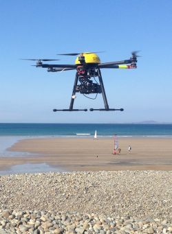
Pembrokeshire County Council recently surveyed the entire shingle bank at Newgale in only four hours using a specialist drone.
The machine carries a high resolution digital camera to produce photographs that overlap by 80 per cent in a technique called aerial photogrammetry.
Hundreds of photographs can be combined to produce an accurate grid of points over the area being surveyed.
This can then be used in contour plans or computer-aided design drawings – as well as producing a photograph of the site – that can be accurately overlaid on a map.
This survey work would take a team several days to complete using ground-based equipment while producing the aerial photograph would need a small aircraft carrying a specialist camera.
It is hoped to be able to regularly monitor the shingle bank, particularly after winter storms, to see how the bank is changing.
Caption
The drone in use at Newgale.
Help keep news FREE for our readers
Supporting your local community newspaper/online news outlet is crucial now more than ever. If you believe in independent journalism, then consider making a valuable contribution by making a one-time or monthly donation. We operate in rural areas where providing unbiased news can be challenging. Read More About Supporting The West Wales Chronicle


