HISTORY buffs can now experience the nooks and crannies of 19th Century Swansea in more detail than ever.
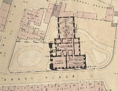
Staff at the West Glamorgan Archive Service in Swansea Council have digitised a giant map of the city that was first published in 1852.
The map, which measures about 132 square feet, was put together to help with planning after the Swansea Local Health Board was formed to regulate sanitation. Produced by London surveyor Samuel Grant, the map took two years to complete.
Downpipes, doghouses, stables, sundials, pumps and piggeries are all included on the map. The houses on the map are all numbered and seating plans are included for large public buildings.
The map is now available for use as an interactive resource CD, which costs £14.95.
Cllr Robert Francis-Davies, Swansea Council’s Cabinet Member for Enterprise, Development and Regeneration, said: “This map is one of the many historical gems that’s available at the West Glamorgan Archive Service in the Civic Centre. Its level of detail means users can explore some of the city’s long-forgotten nooks and crannies and experience what Swansea life was like in 1852.
“The sheer size of the map meant it had been a fairly tricky resource to use for many years, but its digitisation will now allow people to bring the past back to life far more easily with a click of a mouse.
“The CD will prove a hugely useful tool for amateur historians, students and schoolchildren for many years to come.”
Other features of the new CD include a street index, photographs and engravings of some of the places on the map that no longer exist. Users can also zoom in on the map to see each property in detail.
The CD includes a transcript of George Thomas Clark’s 1849 street-by-street survey. Other features include a full account of how the map came to be made and what it tells us about Victorian Swansea.
Andrew Dulley, from the West Glamorgan Archive Service, said: “The detail of the map is extremely impressive. Take Bennet Court as an example – it might sound quite grand, but the map shows it was actually a row of four tiny one-up-one down houses that shared a single toilet and fronted onto an alleyway where people could barely pass without bumping shoulders. A coachmaker’s workshop was also nearby as well as the peaceful garden of a gentleman’s town house. What the map shows is that poverty and wealth were sometimes located very close to one-another.”
Go to www.swansea.gov.uk/westglamorganarchives to find out more or call 01792 636589.

| [donate]
| Help keep news FREE for our readersSupporting your local community newspaper/online news outlet is crucial now more than ever. If you believe in independent journalism,then consider making a valuable contribution by making a one-time or monthly donation. We operate in rural areas where providing unbiased news can be challenging. |


